Exercise 1.
Water Balance of the 1993 Midwest Flood
CE 394K Surface Water Hydrology
University of Texas at Austin
Prepared by David R. Maidment and Pawel Mizgalewicz
Table of Contents
In 1993, the Midwestern States of the United States suffered their
worst flood in more than 40 years. Heavy rains sustained throughout
the summer flooded Iowa and portions of surrounding States. President
Clinton appointed a team called the Scientific Assessment and Strategy
Team
(SAST) to examine the flood events, collect and analyze data, and report on
the policy implications of the flood. How could the effects of
future floods of this type be mitigated through policy changes? Should
levees that breached in the flood be rebuilt? Has the draining of
wetlands in the Midwest created flood hazards downstream? If so,
what effect would recreating some of these wetlands have on flood
discharges?
The SAST team met and worked for several months at the US Geological
Survey's EROS Data Center where they compiled a considerable volume
of data, some of it displayed on the
SAST Home Page.
In February, 1994, the SAST team convened a meeting of
hydrologists and hydraulic engineers from around the United States to
review the team's work and to suggest new lines of activity. It was
fairly clear at this meeting that hydrologic practice at the time
could not address very well the huge regional scope of the flood:
the affected region has an area of approximately 700,000 km2, and
most of the studies presented at the meeting dealt with areas of the
order of 10 to 100 km2.
At this meeting, Dr Maidment proposed that a daily water balance study
should be carried out to look in a spatially distributed way at the
amount of precipitation, evaporation, change in storage, inflow and
outflow of water in the region. This study was eventually funded
by the US Geological Survey and jointly undertaken by the Center for
Research in Water Resources of the University of Texas at Austin, and
the Department of Geography of the University of Utah. Its methods
and preliminary results can be reviewed on the
SAST Water Balance Page.
This exercise is based on some of the data generated in that study.
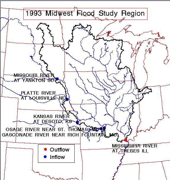
The data presented here are for the SAST region taken as a single unit,
comprising all the drainage area of the Upper Mississippi River and
a portion of the Missouri River drainage, primarily capturing westward
flowing water from Western Iowa. There are five inflow points to
the study region where flow coming into the Missouri River from
Eastward flowing tributaries enters the region. There is one outflow
point, the Mississippi River at Thebes, Illinois, just above the
confluence of the Mississippi and Ohio Rivers. All inflows and outflow
points are monitored by USGS gages reporting daily discharge.
Daily precipitation over the region is estimated by interpolation from
records of more than 1000 gages. Daily evaporation over the region
is estimated by taking National Weather Service Maps of potential
evaporation, and finding the factor (0.775) which when used to
multiply the potential evaporation ensures that the annual water balance
from January 1 to December 31, 1993, is approximately closed.
- To provide experience in analyzing the water balance of a large region
- To practice using spreadsheet programs for hydrology
- To learn something about the 1993 Midwest flood.
This exercise is intended to be performed on a spreadsheet program on
a personal computer. The data
are in a comma delimited text format called midwest.csv
that can be directly imported into Excel or
another spreadsheet program.
Dowload the water balance data.
Comma-delimited text file: midwest.csv
Excel file: midwest.xls
The data will display on the screen. If you download the Excel file
the result doesn't look very intelligible because it is a binary file.
Under Netscape, use File/Save As to save the
data to a directory where you want to do the analysis.
The data consist of:
Column 1: Date expressed as PYYMMDD, where YY is the year (93) MM is
the month, and DD is the day of the month
Column 2: Outflow [m3/s] from the region (discharge measured in the
Mississippi R. at Thebes, IL.)
Column 3-7: Inflow [m3/s] into the region measured at five sites where
rivers drain into the study region from the West:
- Osage River near St Thomas, Missouri
- Gasconade River near Rich Fountain, Missouri
- Missouri River at Yankton, South Dakota (the discharge from the upper
Missouri basin which enters the study region)
- Platte River at Louisville, Nebraska
- Kansas River at DeSoto, Kansas
Column 8: Average Precipitation over the Region[mm/d]
Column 9: Average Evapotranspiration over the Region[mm/d]
Drainage area within the study boundary = 698525 km2
Conversion factors:
1 d = 86400 s
1 m = 1000 mm
1 km = 1000 m =
1,000,000 mm
1 cfs = 0.028317 m3/s
1 in = 2.54 cm
1 m = 3.2808 ft
The daily water balance is to be constructed for 365 days,
1 January to 31 December 1993.
- Convert the outflow series of the Mississippi River at
Thebes, Ill, into a series of equivalent depths in mm/day by
converting the daily discharge into an equivalent volume in m3/day
and then dividing by the drainage area.
- Aggregate the five inflow series into a single total inflow series
and similarly convert the total to an equivalent depth of water in
mm/day by dividing by the drainage area.
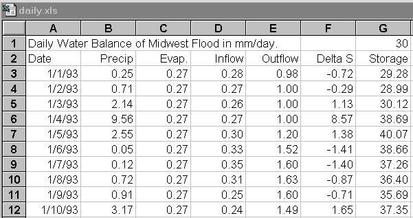
- Construct a spreadsheet with date in the first column and the
succeeding four columns being precipitation, evaporation, inflow
and outflow, all in mm/day. To make a date field in Excel, type
1/1/93 in the first column, use a formula to add 1 to get the date
in the next row in this column, then copy the result to succeeding
rows.
- Add two additional columns, the change in storage each day
computed as:
Change in Storage = Precip - Evap + Inflow - Outflow
and the total accumulated storage in the region, assuming that
the storage was initially 30mm on 1 January 1993.
The result should look something like this:
- Determine the annual total precipitation, evaporation,
inflow, outflow and change in storage for the region. Is
the annual water balance reasonably closed?
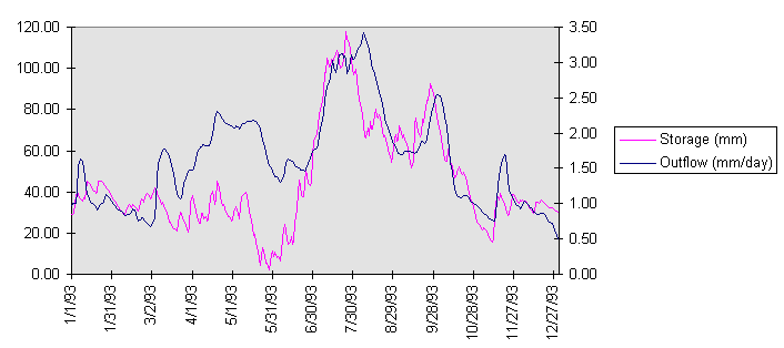
- Plot a graph showing the outflow in mm/day and the storage
in mm against the date. Prepare the graph in the usual way in
Excel and then click on the outflow line once the graph is plotted,
bring up a dialog box, click on "axis" and select "secondary" to
get both the outflow and the storage plotted with different y axes.
The result should look something like this:
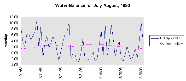
- It appears that the bulk of the flood occured over a two
month period from 1 July to 31 August 1993. Prepare a new
spreadsheet for this period. Determine the series (precipitation
- evaporation) and (outflow - inflow), all in mm/day and plot them.
The result should look something like this:
RESULTS TO BE TURNED IN:
- The total annual precipitation, evaporation, inflow, and outflow
in mm for
1993. What is the annual net outflow (outflow - inflow) in mm?
What percentage of the annual precipitation within the region evaporated and what
percentage drained out of the region in the Mississippi River?
- A graph showing the storage (mm) and the discharge (mm/day)
for the period Jan 1 to December 31, 1993. What
was the peak depth of storage on the land surface? When did it
occur? What was the peak discharge (mm/day and m3/s) at the outflow
point? When did it occur? What was the lag time between the peak
storage and the peak discharge?
- Present a spreadsheet showing the daily water balance analysis for July and
August 1993. This should include date, precipitation, evaporation,
inflow, outflow, change in storage and storage, in mm. Plot
a graph showing (precipitation - evaporation) and (outflow - inflow).
What effect does flow through the region have on smoothing the
time variations in precipitation?
- For this two month period, what was the total precipitation,
evaporation, inflow, outflow and change in storage in mm? What
was the net outflow (outflow - inflow) in mm? What percentage
of the precipitation left the region as evaporation? What
percentage of the precipitation flowed out of the region as net
outflow?
- Do something interesting with the data that has not been
requested as part of this exercise. Analyse some aspect of this
problem and present a brief description of what you have determined.
Go to Course Home Page