Engineering Computer Graphics Laboratory, Brigham Young University
The Engineering Computer Graphics Laboratory at Brigham Young University has created a Groundwater Modeling System (GMS) whose latest version includes a Map Module that links GMS with Arcview and Arc/Info shapefiles, coverages, grids and attribute tables. The framework for the Map Module is based on a vector GIS data model with points, lines, and polygons. As a result, coverages can be shared between GMS and Arc/Info using the generate and ungenerate commands in Arc/Info. Shapefiles can be used to transfer data between GMS and ArcView.
The Groundwater Modeling System (GMS) is a comprehensive graphical user environment for performing groundwater simulations. The entire GMS system consists of a graphical user interface (the GMS program) and a number of analysis codes (MODFLOW, MT3D, MODPATH, SEEP2D, FEMWATER). The GMS interface was developed by the Engineering Computer Graphics Laboratory of Brigham Young University in partnership with the U.S. Army Engineer Waterways Experiment Station.
GMS was designed as a comprehensive modeling environment. Several types of models are supported and facilities are provided to share information between different models and data types. Tools are provided for site characterization, model conceptualization, mesh and grid generation, geostatistics, and post-processing. GMS includes a new suite of tools in the Map Module for creating high level representations of groundwater models using GIS objects. These models can be imported/exported between GMS and Arc/Info or ArcView.
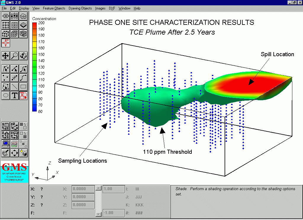
Figure 1. A 3D Contaminant Plume Modeled with GMS.
With the current state of the art in groundwater modeling, simulations are typically performed according to the following steps:
The first step, the development of a conceptual model, is often the most important step in the modeling process. A conceptual model is a simplified, high-level representation of the site to be modeled. If the conceptual model is not developed properly, steps 2&3 result in wasted effort since it will be impossible to calibrate the model in step 4. In many cases, the user must develop several conceptual models before proper calibration is achieved. This is particularly true in groundwater modeling where appropriate boundary conditions and stratigraphic representations are often difficult to determine. Most groundwater modeling pre-processing software is designed to automate and enhance to work involved in steps 2-5. The conceptual model is developed independently of the modeling software. A new approach to model development has been incorporated into GMS which not only includes the conceptual model as part of the computer-assisted modeling process, but features the conceptual model as the primary focus of model generation and data entry process. Rather than focusing the model generation and data entry on a numerical grid or mesh, the user creates a conceptual model using GIS objects and assigns boundary conditions and model properties to the conceptual model. The conceptual model is defined in a general purpose fashion that is independent of grid type (finite element, finite difference, etc.) and to some degree, independent of the analysis code to be used. Once the conceptual model is defined at this higher level, the numerical model is automatically generated from the conceptual model. The grid or mesh is constructed in a manner that fits or adapts the grid to the conceptual model and the boundary conditions and material properties are extracted and assigned to the appropriate cells or elements.
Conceptual models are constructed in the new Map Module of GMS. A sample conceptual model is shown in Figure 2. The conceptual model has been constructed on top of a scanned USGS quad map which has been imported to GMS and registered to the correct world coordinates on the GMS desktop. The objects in the conceptual model consist of sets of points, arcs, and polygons organized into coverages (layers). The data model used in GMS for GIS objects is patterned after the Arc/Info data model. Thus, these objects can be constructed within GMS or imported/exported from either ArcView or Arc/Info.
Once the GIS objects are created, attributes are assigned to the objects. For example, for a drain arc, the conductance of the drain would be assigned to the arc and the elevation of the drain would be assigned to the endpoints (nodes) of the arc. The elevation would then vary linearly along the length of the arc.
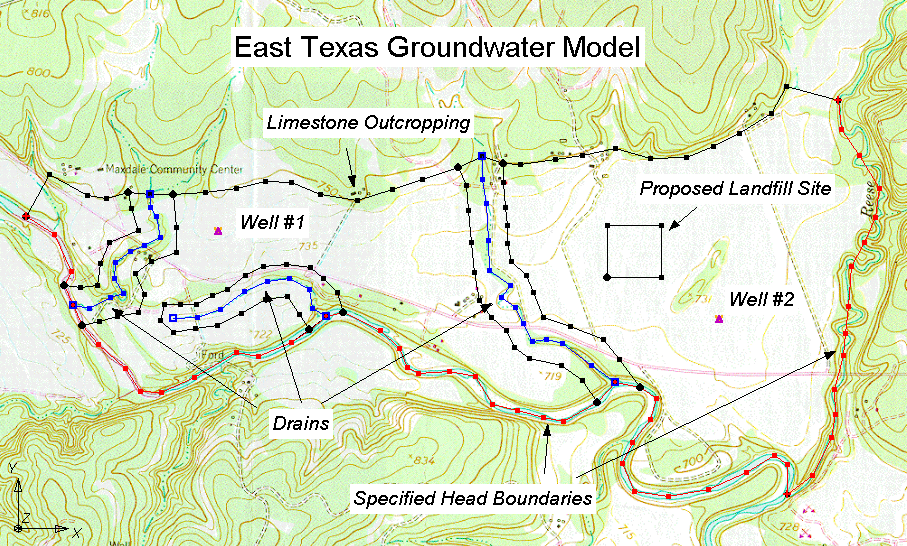
Figure 2. A Conceptual Model Generated From GIS Objects.
Once the conceptual model is constructed, a grid is automatically constructed by GMS (Figure 3). The grid can be rotated if necessary to achieve the best fit with the conceptual model. The spacing of the rows and columns in the grid is adjusted so that the grid is refined around the wells or other points where a large gradient in heads is expected and the cells outside the model domain are inactivated. Finally, the GIS objects are overlaid on the computational grid and all stresses (rivers, wells, drains, gen. head, constant head), recharge zones, hydraulic conductivity zones, etc. are automatically assigned to the grid cells in the appropriate MODFLOW format.
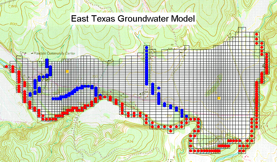
Figure 3. Grid and MODFLOW Data Constructed From the Conceptual Model.
Once the conceptual model has been converted to a grid-based MODFLOW numerical model, MODFLOW can be launched from the GMS menu. Once the MODFLOW solution is complete, the MODFLOW solution can be imported to GMS for plotting (Figure 4).
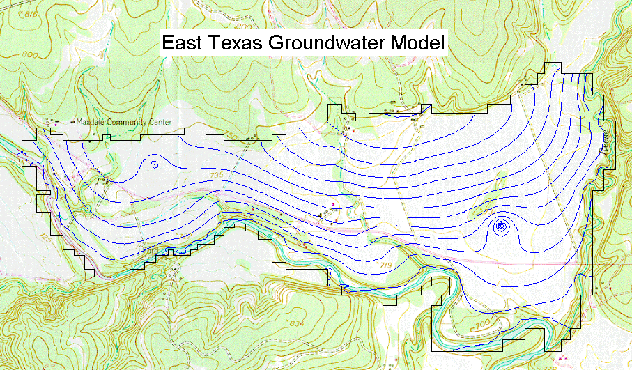
Figure 4. Sample Head Contours.
Once a conceptual model has been created in GMS in the GIS format, the model can be exported to Arc/Info or ArcView using shapefiles. The model can then be stored in the GIS for archival purposes, or used to generate professional quality maps for documentation of the model. The East Texas model shown above after being imported to ArcView is illustrated in Figure 5. Points, arcs, and polygons defined in Arc/Info or ArcView can also be imported to GMS.
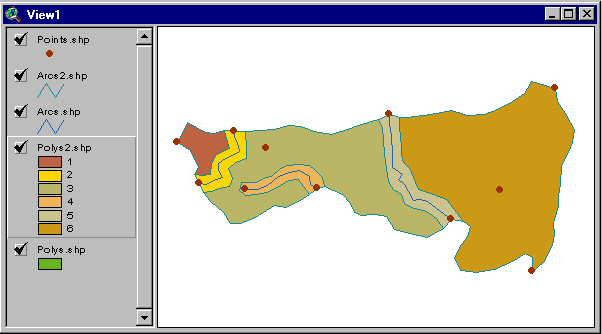
Figure 5. Model After Importing in ArcView.
The conceptual model approach has numerous advantages over the traditional cell by cell approach for model input. First of all, the defining a model using GIS objects is much faster and much simpler than the traditional cell-based approach. Complex models can be defined quickly and easily. Second, once a simulation is performed, changes to the model can be made by changing the GIS objects in the conceptual model and regenerating the grid data. For example, suppose a model contained a no-flow boundary corresponding to a groundwater divide. After running a simulation it may be determined that the groundwater divide should be repositioned. This can be easily accomplished in GMS by graphically repositioning the no-flow arc in the conceptual model and reconverting the conceptual model. The entire process takes only seconds. As a result, numerous configurations of the conceptual model can be evaluated in the time normally required to perform a single simulation.
The conceptual model tools described in the previous section also can be used as a powerful method for generating 2D finite element meshes. For example, the same GIS objects shown in Figure 3 can be used to generate the finite element mesh shown in Figure 6. These meshes can used with the SEEP2D model or they can be used in the construction of 3D meshes for input to FEMWATER.
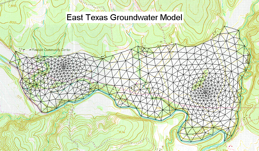
Figure 6. Mesh Constructed from Conceptual Model.
The conceptual model GIS approach can also be used to define MODPATH models in GMS. MODPATH is a particle tracking code developed by the USGS that was designed to work in conjunction with MODFLOW. After running a MODFLOW simulation, the user can designate the location of a set of particles. The particles are then tracked through time assuming they are transported by advection using the flow field computed by MODFLOW. Particles can be tracked either forward in time or backward in time. Particle tracking analyses are particularly useful for delineating capture zones or areas of influence for wells. A set of pathlines computed from a backward tracking analysis from a well is shown in Figure 7. The pathlines can be exported from GMS is dxf format and imported to ArcView for capture zone mapping.
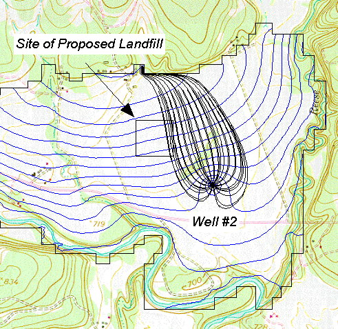
Figure 7. Capture Zone for a Well Delineated by MODPATH.
The GIS approach can also be used to MT3D models. MT3D is a modular three-dimensional transport model for the simulation of advection, dispersion, and chemical reactions of dissolved constituents in groundwater systems and was written by Chunmiao Zheng. MT3D uses a modular structure similar to the structure utilized by MODFLOW. MT3D is used in conjunction with MODFLOW in a two step flow and transport simulation. Heads and cell to cell flux terms are computed by MODFLOW during the flow simulation and are written to a specially formatted file. This file is then read by MT3D and utilized as the flow field for the transport portion of the simulation. A sample contaminant plume computed by MT3D for the MODFLOW problem illustrated above is shown in Figure 8. The plume contours can be exported to ArcView for final report generation.
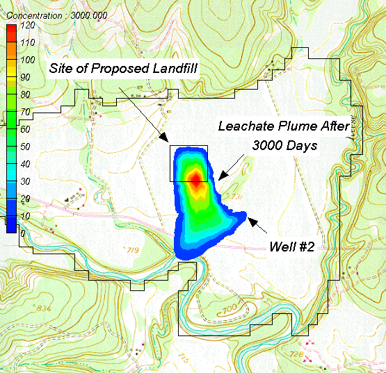
Figure 8. Leachate Plume from a Landfill Modeled by MT3D.
The conceptual model approach is currently supported in GMS for the MODFLOW, MODPATH, and MT3D models. GIS objects can be used to generate meshes for SEEP2D and FEMWATER but boundary conditions and material properties cannot be assigned to the GIS objects for these models. However, the conceptual model approach is currently being extended in GMS to include complete support for the SEEP2D, FEMWATER, and PARFLOW models. Furthermore, the current version of GMS can be used to exchange geometric data between GMS and ArcView and Arc/Info, but attrtibutes are not exchanged. The next version of GMS will support full import/export capabilities, including both geometry and attributes. One of the dialogs currently under development for importing shapefiles and mapping attributes to the appropriate data structures is shown in Figure 9.
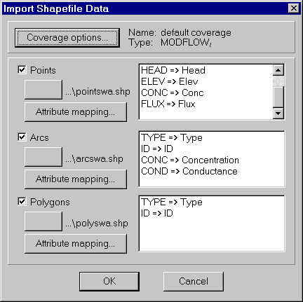
Figure 9. Importing Shapefiles with Attributes.
More information about GMS can be obtained from the GMS web pages at:
http://www.ecgl.byu.edu/software/gms/gms.html
A free demo version of GMS can be downloaded from this site. In addition, the complete GMS documentation is available in Adobe Acrobat format (*.pdf).
These materials may be used for study, research, and education, but please credit the authors and the Engineering Computer Graphics Laboratory, Brigham Young University. All commercial rights reserved. Copyright 1997 Engineering Computer Graphics Laboratory.
