This exercise is modified from the exercise "Nonpoint Source Pollution in the Mission Basin" from the GISHydro97 Loads Module. The original exercise was prepared by Ann Quenzer, Ferdi Hellweger and David Maidment. One of the main features that distinguishes this exercise from the original version is that the whole exercise can be executed using PC Arcview. In addition, the process has been simplified, and an interface has been built so that the user complete the exercise without having to edit the scripts.
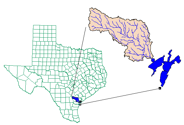
The purpose of this exercise is to show how Arcview 3.0 with the Spatial Analyst and Hydrologic Modeling Extensions can be used to provide estimates of nonpoint source pollutant loads to a receiving body of water. For this exercise, the receiving water is Copano Bay in South Texas, into which the Aransas River, Mission River, and Copano Creek all drain. These streams are all contained within the San Antonio-Nueces coastal basin, a 7000 sq km basin which is bounded by the San Antonio River and Nueces River basins (hence the name).
You will use a coverage of land uses in the Mission Basin and associate Expected Mean Concentration (EMC) values of various pollutant constituents with those land uses. Then, for a selected pollutant, you will create an EMC grid and multiply it by a grid of average annual rainfall runoff in the basin. The result will be the annual loading of the constituent to each grid cell in the basin, i.e.
Load = Flow * Concentration, or
L (Mass/Time) = Q (Volume/Time) * C (Mass/Volume)
Finally, you'll perform a flow accumulation on the cell-based loads to determine average annual loads to Copano Bay.
This exercise is executed using ArcView 3.0 or up, with the Spatial Analyst and the Hydrologic Modeling Extensions. The data needed for this exercise are imported from the interchange .e00 files located in the subdirectory gisfiles under the Loads directory on the GISHydro97 CD-ROM. (Interchange files, .e00, can be imported using the import function in Arc Info). For this exercise, the imported data are presented as grids and coverages, which can be viewed directly in ArcView.
*****IMPORTANT****
This exercise is memory intensive! Delete some of the intermediate coverages
and grids as you proceed to avoid running out of space. Delete any unnecessary
files from your disk before running this exercise.
In your C:\temp directory, we have upload a directory call ex6, inside which you will see a directory called NPSP. All the data and application programs needed for this exercise are located in the datasrc subdirectory under NPSP directory. The other two subdirectories are webfiles, which contains an exercise in HTML format and the related web image files; and work, which will be your working directory. Make a subdirectory called gisfiles in the work directory where you will save the files you will create during the exercise.
In datasrc directory, there are two grids, four coverages, an Info directory, the EMC data table and an ArcView project file, as listed below.
Contains info files for the grids and coverages
The customized ArcView Project file for Nonpoint Source Pollution Assessment, NPSP.apr
Internet students can download the necessary files.
Site: ftp.crwr.utexas.edu
Login: anonymous
Password: your e-mail address
Directory: /pub/outgoing/crwr/gishydro/africa/ex6t
The files are contained in a compressed archive called NPSP1.Zip
This part of the exercise is intended for you to familiarize yourself with the region in which you'll be working, the Mission River watershed which drains into Copano Bay on the inner coastal waterway system of South Texas.
Copy the ArcView project file NPSP.apr from directory /ex6/NPSP/datasrc/
to your working directory /ex6/NPSP/work/. Starting the Arcview
3.0 and open the project NPSP.apr in your work directory.
Click on File/Extensions and you will see that the Hydrologic Modeling and Spatial Analyst Extensions have already been added in this project.
You need to take a look at the Digital Elevation Model (DEM) of the
region to familiarize yourself with the landscape. Click on the Project
Window and Open a new view. Change the name of the view to ProjArea
by going to View/Properties. Add the DEM grid from the
datasrc directory to the view by clicking on ![]() ,
change the Data Source Type to Grid Data Source, highlight dem,
and click OK. Once the theme has been added, make the DEM
grid active and check the box next to the theme
,
change the Data Source Type to Grid Data Source, highlight dem,
and click OK. Once the theme has been added, make the DEM
grid active and check the box next to the theme ![]() to view the DEM of the area.
to view the DEM of the area.

You can see part of the Nueces River to the South, and the end of the San Antonio River to the North. Both of these rivers flow into the Texas coastal waterways to the East. The Mission basin which we are going to study in this exercise is the area drained by the Mission River.
Now, lets take a look at some cell elevations within the grid:
Make the DEM theme active by clicking on its display in the legend bar
of the View window. The legend bar seems raised.
Click on the identify tool ![]() ,
then go to the view and click on some points on the grid, you will see
the following:
,
then go to the view and click on some points on the grid, you will see
the following:

The value is the land surface elevations in meters above mean sea level for point #2.
Now lets take a look of this grid. While grid dem is active, choose Theme/Properties, make sure the definition on the left legend bar is selected, and you should see the information of this theme, including Source, Cellsize, Rows, Cols, etc..
Now overlay the basin border, stream network, and bay network:
Make the ProjArea view active. Click on the ![]() button, change the Data Source Type to Feature Data Sources, and
highlight the three feature data sources, misbasin, streams,
and bay, by using the shift key (use the Polygon version of Misbasin
and Bay). Click OK.
button, change the Data Source Type to Feature Data Sources, and
highlight the three feature data sources, misbasin, streams,
and bay, by using the shift key (use the Polygon version of Misbasin
and Bay). Click OK.
Check the three ![]() boxes for the
newly added themes. Change the colors of the themes as desired by double
clicking on the theme symbol to activate the legend editor. Once in the
legend editor, double click on the theme symbol again and use the Color
Palette to change to the desired color. Remember to click the
boxes for the
newly added themes. Change the colors of the themes as desired by double
clicking on the theme symbol to activate the legend editor. Once in the
legend editor, double click on the theme symbol again and use the Color
Palette to change to the desired color. Remember to click the ![]() button when you are done changing the color. It is particularly useful
to make the colored interior of the Misbasin theme transparent so that
you can see the streams and the DEM within the basin. In the Fill Palette,
the transparent option is the clear box in the top left corner of the fill
shading options available.
button when you are done changing the color. It is particularly useful
to make the colored interior of the Misbasin theme transparent so that
you can see the streams and the DEM within the basin. In the Fill Palette,
the transparent option is the clear box in the top left corner of the fill
shading options available.
To view all the themes at once, have the themes in the order of Streams, Bay, Misbasin and DEM from the top to the bottom..
Note that Copano Bay is the interior bay that is enclosed almost all the way around. It looks somewhat like a hammer head. The stream network was created using the watershed delineation process. The threshold value for this particular network was 8000 cells. The basin border was created by delineating all the subwatersheds in the basin, converting those grids to coverages (using the gridpoly command) and then combining the coverages with the Arc/Info mapjoin command. The 3 largest streams that drain to Copano Bay are the Aransas River, Mission River, and Copano Creek.

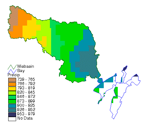
Precipitation in Texas has an East - West gradient and also is higher near the coast than inland. The USDA Natural Resources Conservation Service and Oregon State University are putting out annual and monthly precipitation grids of the United States, developed using an interpolation process called PRISM, and verified by consultation with State climatologists. In this exercise, you will use the portion of this annual precipitation grid for the San Antonio - Nueces basin.
Open a new View. Call this view Precip/Runoff. Using the ![]() button, add the grid precip. The coverages bay and misbasin
should be added to the view in arc format. This is done in the Add Theme
Window by clicking on the little folder next to the theme name. You will
then see the theme expanded with a polygon, arc, labelpoint and node option.
Highlight the arc option and click OK.
button, add the grid precip. The coverages bay and misbasin
should be added to the view in arc format. This is done in the Add Theme
Window by clicking on the little folder next to the theme name. You will
then see the theme expanded with a polygon, arc, labelpoint and node option.
Highlight the arc option and click OK.
When the themes show up in the legend of the view, double click on the
precip symbol to bring up the Legend Editor window. In the Legend
Editor, change the color scheme of precip to get a ramped effect.
Click on the arrow next to the Color Ramps box, scroll down, and select
the Precipitation color scheme. When you are finished, select ![]() in the Legend Editor window and then close both the Legend Editor and Color
Palette. Finally, select
in the Legend Editor window and then close both the Legend Editor and Color
Palette. Finally, select ![]() for the
precip, bay and misbasin themes in the View Legend.
You should be able to easily see the distribution of annual precipitation
in the Mission Basin.
for the
precip, bay and misbasin themes in the View Legend.
You should be able to easily see the distribution of annual precipitation
in the Mission Basin.
Save your project, so if you have a crash you don't have
to recreate it later. You can check the precipitation values at different
locations using identify tool ![]() .
You can also get the grid information of the precipitation grid using Theme/Properties.../Definition.
.
You can also get the grid information of the precipitation grid using Theme/Properties.../Definition.
Through an analysis of USGS Streamflow gages in Texas, our research group has been able to determine the average annual streamflow at those gage locations. The average annual precipitation over the drainage areas upstream of those points was also determined and a mathematical relationship between precipitation and streamflow was established.
A detailed explanationof this process is discussed in Chapter 5 of the CRWR Online Report 97-1, Spatial Water Balance of Texas.
The rainfall/runoff relationship is:
Q = 0.00064 * P (mm/yr) * exp(0.0061 * P)    if P < Po
Q = 0.51 * P (mm/yr)  - 339.1                if P >= Po
Where Q is runoff (mm/year) and P is precipitation (mm/year). An exponential function was fit to the data in drier areas with mean annual rainfall less than Po (801 mm/year). It turns out that a linear function yields a better fit to the wetter watersheds with rainfall above Po.
Make the View window active, choose NPSP Load/Runoff Grid. NPSP stands for Nonpoint Source Pollution. NPSP Load/Runoff Grid runs a script that inserts the precip grid into the rainfall/runoff equations discussed earlier to calculate the runoff grid (mm/yr). You will be asked to choose the view and theme to do the calculation. Choose view Precip/Runoff and theme Precip for this exercise. Thus runoff grid for the Mission River Basin is calculated. The runoff grid is temporally saved in the C:\temp directory. Make sure the temporary grid is active, use Theme/Save Data Set to save the runoff in your gisfiles directoy as Runoffgd. Delete the temporary grid and add in the Runoffgd.
If you want to redefine the rainfall/runoff relationship, which may be more suitable for your study region, you can modify the script. To do so, make the Project Window active, click on the Scripts, a list of available script will show up. Open the script NPSP.rogrid, and modify the equation in the Calculate session according to your rainfall/runoff relationship, then compile the script by clicking on the check button. Now when you choose NPSP Load/Runoff Grid, you will be able to calculate the runoff grid based on your rainfall/runoff relationship.
Once the runoff grid is calculated and added to the view, change the legend colors the same way as the precipitation grid was changed. You may use a different color scheme if desired. Here is an example of what the image should look like.

Make sure the Runoffgd theme is active. Now use the identify
tool ![]() to investigate
values of runoff throughout the basin. You can also view the grid information
using Theme/Properties/definition.
to investigate
values of runoff throughout the basin. You can also view the grid information
using Theme/Properties/definition.
Save your project.
In this part of the exercise, we are going to employ the USGS Land Use
and Land Cover Files. These files use a Anderson
Land Use Code classification system, in which major land use types
are broken out into 9 categories. The first 6 categories are seen in this
basin.
1 = urban
2 = agriculture
3 = rangeland
4 = forest
5 = water
6 = wetlands
7 = barren land
8 = tundra
9 = ice and snow.
The second digit distinguishes subcategories of these principal categories,
e.g.
11 = urban residential
12 = urban commercial
13 = urban industrial, etc.
More information about the land use/land cover files is contained in the
Digital
Library.
This land use classification the United States was made in the late 1970's and land use has changed somewhat in the years since then, particularly as cities have grown. But, the LULC files are still the standard land use classification of the United States taken as a whole. Files based on 1:250,000 map sheet names can be downloaded from the USGS Land Use/Land Cover site. These files are in UTM coordinates which can cause problems because adjacent land use maps can be in different UTM zones. A more convenient source for land use files in Texas is the TNRIS ftp server site under the heading Land Use/Land Cover (ascii data).
The original file downloaded from the Internet was in .e00 format, and it contained much larger region from which the land use data of the mission basin (mislu)can be retrieved. You can use clip command in Arc/Info (or the map calculator in ArcView) to retrieve the data. Details of how to do this can be found in the previous version of the exercise "Nonpoint Source Pollution in the Mission Basin".
Open a new View in ArcView. Use View/Properties to change the name of the View to Land/Load. Add the polygon coverage of land use in the Mission basin, mislu, as a theme. To display the individual land use categories, double-click on the mislu theme symbol, and use the resulting Legend Editor to change the Legend Type to Graduated Color and the Classification Field to lanuse-id. Click on the Classify button and change the number of classes to 8. Click on the Value buttons to change the values of each category. Click on the Label buttons to change the labels of each category. Use the Fill Palette to color-code each of the symbols into land use categories. The following color scheme works pretty well, but feel free to use your own:
        Value   Label           Symbol Color

        0       Unknown         White (or transparent)
        10-17   Urban           Red
        20-24   Agriculture     Tan
        30-33   Rangeland       Yellow
        40-43   Forestland      Green
        50-54   Water           Medium Blue
        60-62   Wetlands        Light Blue
        70-76   Barren          Gray
Close the Fill Palette and select ![]() in the Legend Editor. Now select
in the Legend Editor. Now select ![]() for the mislu theme in your view and note where all the different
land use categories in the basin are. Save the project for future use.
If you are satisfied with the legend, you can save the legend file for
the future use. In the Legend Editor, click on Save to save the
legend file in your gisfiles directory as landuse.avl (Arcview
legend for land use coverage). Next time you use a coverage with the Anderson
Land Use Code classification system, you can use load button in Legend
Editor to load the legend file and quickly reconstruct a consistent legend.
for the mislu theme in your view and note where all the different
land use categories in the basin are. Save the project for future use.
If you are satisfied with the legend, you can save the legend file for
the future use. In the Legend Editor, click on Save to save the
legend file in your gisfiles directory as landuse.avl (Arcview
legend for land use coverage). Next time you use a coverage with the Anderson
Land Use Code classification system, you can use load button in Legend
Editor to load the legend file and quickly reconstruct a consistent legend.
Save your project.

Now you are going to associate Expected Mean Concentration (EMC) values of various pollutant constituents to the land use types. The Natural Resources Conservation Service of the US Dept. of Agriculture (USDA-NRCS) has provided us with a table of some EMC values for 18 different constituents.
The values in this table are typical concentrations of pollutants found in runoff water from each particular land use. The values are compiled from many field studies done by the US Geological Survey and other organizations.
Note that there are different EMC values for each of the Urban Land Use codes (residential, commercial, industrial, transportation, mixed) but only one EMC value for the Agriculture, Rangeland, and Barren Land Use categories. In addition to this table, we will use the Rangeland EMC values for Forest Land Uses. When you are done viewing this table, minimize it.
This exercise was originally designed to estimate annual loadings of nutrients to the Copano Bay. However, we will limit our study to Phosphorus.
A DBF file emc.dbf has been prepared for this exercise. This is an edited version of the emc table that you previously viewed. It has two columns of data representing lanuses-id and total phosophorus.
You'll need to join these EMC values in the DBF file to the mislu polygon attribute table in order to associate them with the land use.
Add another mislu theme to the view Land/Load. Choose Theme/Properties,
and rename the theme name from mislu to EMC. You can view
the attribute table for the EMC theme by clicking on Open Theme Table button
![]() .
.
In ArcView project window, highlight the Table icon, a list of tables will show up, one of which is the Attributes of EMC. Notice there is no TP concentration in the table yet.
In ArcView project window, highlight the Table icon, click on Add, and locate the emc.dbf from your gisfiles directory. Check the values against the table emc.txt to verify their accuracy. Now you are ready to join the emc.dbf table to the Attributes of EMC.
Click on the emc.dbf table and make it active, the title bar become blue. Click on the field name Lanuses-id and the name seems indented. Click on the Attributes of EMC and make it active, then click on the Landuses-id and make it indented. Here the order of the sequence is important. The first table will be join to the second table. Now choose Table/Join, the emc.dbf table will be joined to the Attributes of EMC table.
Now you can view the Phosphorus distribution in the mission basin. In
the view Land/Load, double-click on the legend bar of the EMC theme
to bring up the Legend Editor. In the Legend Editor, select the Legend
Type to be Graduated Color, the Classification Field to be Tp, and
select 8 classification fields. This will cause the symbol color to ramp
from a light color for 0 mg/L to a darker color for the Max EMC. Again,
close the Fill Palette and ![]() your
changes from the Legend Editor window. Select
your
changes from the Legend Editor window. Select ![]() for the EMC theme in your the view to see the Phosphorus EMC map
for the Mission Basin.
for the EMC theme in your the view to see the Phosphorus EMC map
for the Mission Basin.
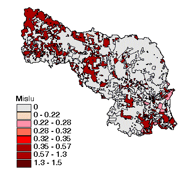
Notice the large area in the north-east of the basin that contributes 0 mg/L of Total Phosphorus. This corresponds to forest and rangeland land uses which do not contribute much phosphorus to runoff because fertilizers are applied to this land and it is not disturbed by land cultivation. The main nonpoint source of phosphorus is from the agricultural lands in the South side of the basin. There can also be significant point sources of phosphorus from municipal treatment plant effluent.
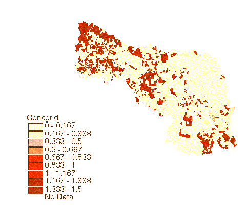
We will now convert the land use theme to an equivalent grid showing the Total Phosphorus concentrations in mg/l over the landscape. Choose NPSP Load/EMC grid, a Convert to Emc dialogue pops up. Locate your gisfiles directory, and name the grid as emcgrid, click OK. In the following dialogue box Conversion Extent: EMC, choose Same As EMC for Output Grid Extent, As Specified Below for Output Grid Cell Size, and 100 for CellSize, click OK. Then choose Tp for Pick field for cell values, click OK. You will be asked Add grid as theme to the View. Click Yes. A new theme similar to the EMC coverage will be added to the view. However, this theme is a grid not a coverage like the previous emc theme. You can get a description of emcgrid by selecting Theme/Properties/Definition from the View Menu bar.
Save your project.
LAND
We will now convert the emcgrid to a grid showing the Total Phosporus Loadings on the land surface in Kg/d.
Add the runoff grid runoffgd from your gisfiles directory
to the Land/Load view by clicking on the ![]() .
.
The land surface loadings grid is calculated by multiplying the concentration grid by the runoff grid.
A conversion factor is used to make a conversion of mg/l (concentration grid) * mm/yr (runoff grid) to the Kg/d (loading grid). This is a more conventional way of looking at loadings. The conversion factor, 1/36525, is used because the input units are mm/yr for runoff and mg/l for concentration, the output units are kg/d for loading; there are 1,000,000 mg/kg, each cell has a 10,000 m2 area, and there are 365.25 days/year.
In effect, for each cell, the load is computed as
Load (kg/d) = Runoff (mm/yr)* Concentration (mg/l) * Cell Area (10000m2)/36525
You will use Map Calculator to do the calculation. Choose Analysis/Map
Calculator from the view menu bar. In the Map Calculation1 dialogue
box, double click Runoffgd followed by the multiplication sign ![]() .
Double click Emcgrid, followed by
.
Double click Emcgrid, followed by ![]() ,
and then 36525. You will notice that your sequence has been recorded (in
parentheses) in Map Calculation 1's scratch pad. Click Evaluate.
After a short while, Map Calculation 1 will show up in the view. This is
a temporary file. Use Theme/Save Data Set to save it to your gisfiles
directory as landload. (Make sure the Map Calculation 1 is the active
theme be saving).
,
and then 36525. You will notice that your sequence has been recorded (in
parentheses) in Map Calculation 1's scratch pad. Click Evaluate.
After a short while, Map Calculation 1 will show up in the view. This is
a temporary file. Use Theme/Save Data Set to save it to your gisfiles
directory as landload. (Make sure the Map Calculation 1 is the active
theme be saving).
You can also use NPSP Load/Land Load from the view menu bar to calculate the Land Load. Remember that the results of all map calculations are only saved temporarily. Create a permanent grid by making the temporary grid active and saving it to your own gisfiles directory using Theme/Save Data Set.
Delete the temporary file and add the grid Landload to the view.
Save your project.

WATER
This part of the procedure includes a flow accumulation. In order to perform this, the river system needs to be connected to the bay system. This will allow for the nonpoint source pollution to be picked from a centroid in the bay polygon coverage. You will use the NPSP Load/Connect Bay&River to do this. This procedure drops the elevation of the bays below the elevation of the adjacent land surface. The centroids of the bays are then dropped further so the flow accumulates at the centroid. The values can then be picked from the centroids.
Add to the ProjArea view, the bay arc and polygon themes. Make the bay arc theme, the bay polygon theme and the DEM themes active. Choose NPSPLoad/Connect Bay&River, the program will ask you if you would like to save the temporary data sets. Choose No. The temporary files are not needed. A new temporary grid is calculated, save it to your gisfiles directory as conngrid. Delete the temporary grid and add in the conngrid.
Next a flow direction must be done on conngrid. Make the conngrid theme active and click on Hydro/Flow Direction.
In this exercise you can also use NPSP Load/Flow Direction,
Once the flow direction is done, click on the ![]() to see if the flow direction looks reasonable. As Flow Direction theme
is active, save it to your gisfiles directory as fdir. Delete
the temporary file Flow Accumulation and add in fdir.
to see if the flow direction looks reasonable. As Flow Direction theme
is active, save it to your gisfiles directory as fdir. Delete
the temporary file Flow Accumulation and add in fdir.
Save your project.
RIVERS
We will now accumulate the cell-based values for the annual Phosphorus load to determine downstream values of average annual loads:
Open a new view and call it Water Loadings. Add to the view the flow direction grid fdir and landload grid from your gisfiles directory. Choose NPSP Load/Weighted FlowAccumulation, then choose the corresponding flowdirection grid fdir and load grid landload.
This procedure executes the command that is known as a WEIGHTED flow accumulation. This is an extension of the regular flowaccumulation command which uses the flow direction grid to count the number of cells upstream of each particular cell in the grid. It then stores that particular count as the value for that cell. For the WEIGHTED flowaccumulation command, a weight grid (in this case, landload) is used and the SUM of the values in the cells upstream of a particular cell is what is stored as the value of that cell.
A temporary grid will be calculated. Save it to your gisfiles directory as wfac. Delete the temporary grid and add in wfac.
Zoom into the view Water Loadings and with the wfac active,
use the identify button ![]() to
determine the average annual phosphorus loadings in the Mission River.
Click a few times along the main branch of the Mission River and its tributaries
to see how the loading accumulates from the various parts of the basin.
To make the river easier to see in the flow accumulation grid, you can
classify the data using graduated scale of standard deviations with 1/4
standard deviation units. This has the effect of differentiating the larger
load areas better than the standard classification.
to
determine the average annual phosphorus loadings in the Mission River.
Click a few times along the main branch of the Mission River and its tributaries
to see how the loading accumulates from the various parts of the basin.
To make the river easier to see in the flow accumulation grid, you can
classify the data using graduated scale of standard deviations with 1/4
standard deviation units. This has the effect of differentiating the larger
load areas better than the standard classification.
Save your project.
Now we are going to identify the phosophorus loads coming into Copano Bay from the Mission River. We will first find the loadings to the river, and then pick the total loadings value which enters in the bay.
First, we will make a series of queries of the load accumulation grid so that you can make a vector map of river sections colored according to the load that they receive.
Begin by making the weighted fac grid wfac active. Click on Analysis/Map
Query.
In the map query, enter the equation: [wfacgrid] > 0.asgrid.
Click Evaluate. This will give you a theme called Map Query 1. Click
on Theme/Properties and rename the theme to Load 0-30. Close
the old Map Query by double clicking on the upper left corner. Each map
query must be closed and started over.
Repeat this procedure for each of the following equations:
Once all the grids are added to the view, you will need to change each to a shapefile. This will make displaying and plotting the river loadings easier.
Begin by making the Load 0-30 theme active. Click on Theme/Convert to Shapefile. Name the file Load0, save it in your gisfiles directory, and add the new theme to the view. You will notice this version of Spatial Analyst can not directory convert line grid to line shapefile, instead it gives polygon shapefile. You need to use the Legend Editor to make the symbol of zero value transparent. The newer version of Spatial Analyst can directly convert the line grid to line shapefile. Double click on the legend box to bring up the Legend Editor, choose Unique Value for Legend Type, and Gridcode for Value field. Do this for each of the remaining river loading grids. Change the colors of the theme symbols to reflect the graduated loadings to the bay (0-30 being the lightest color and >150 being a darker color). You will have change the color of each symbol separately, so do your best. You may use the Custom button in the Fill Palette to customize the colors to your like.

BAY
A function called Pick Load is used to connect the loading in the bay to another Avenue program called Balance which simulates dispersion in the bay. Balance can be run to show how the concentration of the constituent in the bay changes due to this loading. This connection between the land and water constituent transport simulation models is still being refined. Information about Balance can be read at the Internet Site http://www.ce.utexas.edu/prof/maidment/GISHydro/ferdi/research/balance/balance.html. and on GISHydro97 CD-ROM in the GH-Quality Module.
You can now remove all the contents of the work directory.
DO KEEP the original NPSP.apr file, it has modified menus and related avenue scripts which you will not get with the ordinary ArcView interface.
Ok, you're done!
These materials may be used for study, research, and education, but please credit the authors and the Center for Research in Water Resources, The University of Texas at Austin. All commercial rights reserved. Copyright 1997 Center for Research in Water Resources.