
Hello. This is my research home page. I graduated with my Master's degree in Environmental Engineering from The University of Texas at Austin. My research advisor was Dr. David Maidment. I studied the application of Geographic Information Systems (GIS) in a watershed-scale assessment of the total loadings and water quality for the the Corpus Christ Bay System. I am now employed with HDR Engineering, Inc. in Portland, OR.
ROAD MAP TO MY RESEARCH HOMEPAGE
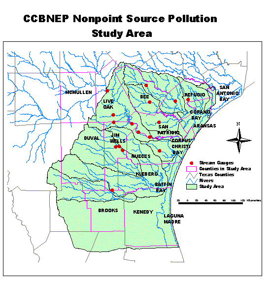
The project is sponsored by the Corpus Christi Bay National Estuary Program (CCBNEP).
This is the study area. (Click on the little map to get a better view.)
I wrote an exercise to explain the procedure for my research. This exercise uses a small watershed within my study region, and the majority of the procedure used for my research.
Here is a presentation concerning my research.
My thesis, A GIS Assessment of the Total Loads and Water Quality for the Coprus Christi National Estuary Program, is done and can be read using the Adobe Acrobat Reader.
ANALYSIS FOR THE CITY OF AUSTIN
Here is an explanation that I wrote which explains how to use the step-wise multiple regression tool in Statsgraphics Plus. I used the program to do a monthly concentrations analysis using Fourier Series.
STATSGO SOILS DATA AND LAND USE
Here is an exercise I wrote which explains the relationship between Statsgo soils data and land use.
Here is an exercise that I helped to write which introduces the EPA model BASINS2. It uses Texas data and introduces data management and data inquiries.
Here is an exercise that I helped to write which explains how to use the NPSM model in the EPA model BASINS2. It uses a watershed in Texas south of the City of Austin.
Here is an exercise that I helped to write which explains how to use the Qual2E model in the EPA model BASINS2. It uses part of a river in Texas within the City of Austin.
I received my Bachelor of Science in Civil Engineering from South Dakota State University