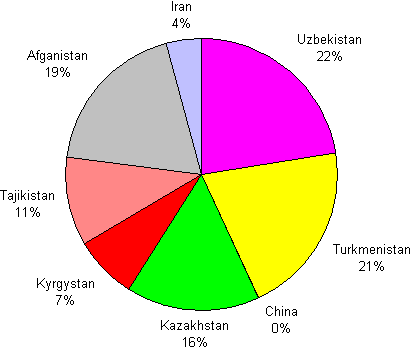
Figure 16: Percent Basin in Each Country
To determine the extend of the watershed within each country, the intersect
command was used to intersect the watershed coverage with the political
country coverage.
The results were interesting. Most of the basin lies Uzbekistan, Turkmenistan,
Afganistan and Kazakhstan. The pie chart below illustrates the divison
of the basin more clearly.
Figure 16: Percent Basin in Each Country
The calculated values were then compared to documented values. The area of the Aral Sea basin referenced to January 1987 was found in the Diagnostic Study for the Development of an Action Plan for the Conservation of the Aral Sea. The figure below shows the comparison between the documented and calculated values.
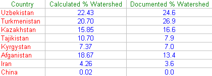
Figure 17: Comparison of the Computed and Documented Basin
One should note that the calculated values for the two upstream countries, Kyrgystan and Tajikistan, are lower than the documented values. However, the calculated values for the downstream countries, Uzebkistan, Tajikistan, and Turkmenistan, are higher than the documented values.